The Oceanography of Cubagua
The Wind, the River, and the Deep Basin That Made Cubagua Possible
There is a moment, sometime in December, when the Caribbean changes its character entirely along the northeastern coast of Venezuela. The trade winds, which blow year-round across the Atlantic from the northeast, suddenly intensify. The sky clears. The air dries. The sea surface, which has spent months absorbing the warm, silty influence of the great rivers draining the South American interior, begins to shift. Surface water is pushed away from the coast by the strengthening winds. And then, rising silently from depths of several hundred meters, cold water begins to climb.
It carries with it everything the sunlit surface layers have spent months exhausting: nitrates, phosphates, silicates, dissolved minerals, and the accumulated biological wealth of the deep. Within days of reaching the surface, those nutrients trigger an explosion of microscopic life. Phytoplankton bloom across vast stretches of sea. The water turns from blue to green. Sardines gather in enormous concentrations, pursued by dolphins, whales, and clouds of marine birds. The shallow coastal banks teem with filter-feeding organisms drawing sustenance from the sudden abundance.
Among them, anchored to the rocky carbonate platforms between the islands of Cubagua, Coche, and Margarita, the Atlantic pearl oyster — Pinctada imbricata — begins to feed.
The Island That Should Not Have Existed
Cubagua itself offers almost nothing. No rivers. No forests. No agricultural soil. No dependable fresh water. Its surface is a flat, wind-scoured expanse of limestone and thorn scrub, receiving barely enough rainfall each year to interrupt what is effectively a desert landscape. Even its modest elevation — the island rises only thirty-two meters at its highest point — means it provides no shelter and no resources capable of sustaining a permanent population beyond the most temporary encampment.
What makes Cubagua extraordinary has nothing to do with the island. It lies entirely in the water surrounding it.
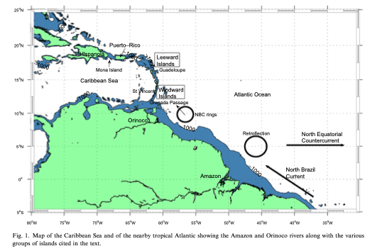
To understand why the Pearl Coast produced what it did — pearls in a volume and quality unmatched by any other marine environment in recorded history — one must follow four converging forces across hundreds of kilometers of ocean, river, and atmosphere: the Orinoco River, the northeast trade winds, the Cariaco Basin, and the shallow carbonate banks of the southeastern Caribbean shelf. Each is essential. Together, they create a biological engine of exceptional and enduring power.
The River
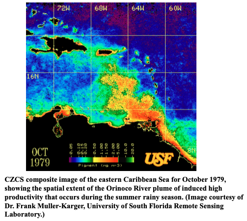
The first force begins far inland, in the Guiana Highlands of southern Venezuela, where the Orinoco River rises and begins its vast arc through one of the largest drainage basins in South America. By the time it reaches the Atlantic, the Orinoco ranks among the four largest rivers in the world by discharge. It carries not merely water but an entire continental ecosystem: dissolved minerals, nitrogen, phosphorus, silica, suspended sediment, and organic matter drawn from the rainforests and savannas of Venezuela and Colombia across a drainage basin approaching 880,000 square kilometers.
During the rainy season — from roughly May through November — the river swells dramatically. At peak discharge in August, flow rates reach approximately 70,000 cubic meters per second. What enters the sea is a freshwater plume of extraordinary scale. Because freshwater is less dense than seawater, it spreads across the surface in vast lenses, carried northwestward along the Venezuelan coast by the prevailing Guiana Current. Modern satellite observations confirm that this plume extends more than 1,600 kilometers from the Orinoco Delta, covering an area exceeding 160,000 square kilometers of the southeastern Caribbean.
The plume produces two effects that are directly relevant to the Pearl Coast. The nutrients it carries stimulate surface productivity wherever the freshwater mixes with coastal waters, seeding the marine food web with raw biological material. And equally important for the history of pearl diving: it makes the water warm, low in salinity, turbid, and visually opaque. During peak rainy months, the sea around Cubagua is transformed. The sixteenth-century chronicler Francisco López de Gómara recorded that at certain times of year the sea turned reddish or darkened over great distances, attributing the change to the oysters themselves. He misunderstood the mechanism, but he was accurately observing a real and recurring environmental event — the Orinoco's seasonal arrival at the Pearl Coast.
This is the season when diving becomes impossible. The sea is murky, warm, and biologically subdued near the surface. But it is also being primed. The nutrients entering coastal waters during the rainy season deposit the raw material that the dry season's upwelling will then put to explosive use.
The Wind and the Upwelling
Between December and April, the northeast trade winds intensify across the Venezuelan coast with a consistency and force that sets this stretch of sea apart from most of the tropical Atlantic. The mechanism they trigger — coastal upwelling through a process oceanographers call Ekman transport — is the single most important physical force in the entire history of the Pearl Coast.
As the trade winds push surface water away from the coast, colder, deeper water rises to replace it. The source of that rising water is the Cariaco Basin: a deep, tectonically formed marine depression running east-west along the Venezuelan continental shelf, directly adjacent to the pearl islands. The Basin consists of two sub-basins, each reaching approximately 1,400 meters in depth, connected to the open Caribbean through shallow sills of only about 140 meters. Because deep water cannot exchange freely with the open ocean, the Basin below roughly 250 meters is permanently anoxic — devoid of oxygen, dense with accumulated organic material, and extraordinarily rich in the dissolved nutrients that centuries of biological decomposition produce.
When the trade winds force surface water offshore and cold water rises from the Basin onto the shallow coastal shelf, the effect on surface productivity is immediate and dramatic. Measurements from the CARIACO Ocean Time-Series Program, which monitored the Basin continuously from 1995 to 2017, confirm that primary production during the upwelling months reaches approximately 1.4 grams of carbon per square meter per day in the upper hundred meters of water — among the highest values recorded anywhere in the tropical Atlantic. Sea surface temperatures drop between two and four degrees Celsius from their wet-season highs. Salinity rises. The water clears. Phytoplankton blooms spread across the shallow banks. The sea turns green with life.
The sediments of the Cariaco Basin preserve a geological record of this cycle that renders it visible across deep time. Because the deep water is permanently anoxic, the seafloor experiences no biological disturbance. Sediments accumulate in undisturbed annual layers — varves — with light-colored laminae deposited during the productive upwelling months alternating with darker, terrestrially influenced layers from the rainy season. Each varve is one year. Thousands of them stack in sequence, recording the same seasonal rhythm that governed pearl diving on the surface above for as long as the trade winds have blown across the Venezuelan coast.
The Oyster and the Seabed
Pinctada imbricata, the Atlantic pearl oyster, is a species precisely calibrated to exploit this kind of seasonal oscillation. Modern biological studies of the Gulf of Cariaco demonstrate that the oyster's growth correlates directly with phytoplankton biomass: during the upwelling months, when microscopic food is most abundant, oyster tissue mass increases, reproductive activity intensifies, and nacre deposition — the biological process responsible for pearl formation — accelerates. During the warm, low-productivity rainy months, growth slows. The pearl is a physical record of that alternating rhythm, its concentric layers of nacre built up season by season in the cold, clear, phytoplankton-rich water that the Cariaco Basin's upwelling makes possible.
The physical geography of the seabed amplifies these biological advantages. The shallow carbonate banks extending between Cubagua, Coche, Margarita, and the Araya Peninsula offer the hard, stable substrate that pearl oysters require for settlement during their larval stage. Rocky ledges, coral fragments, shell accumulations, and carbonate platforms allow oysters to anchor in immense concentrations across extensive areas of seafloor. Water depths on these banks are shallow enough — typically between three and ten meters — for divers to reach the beds by breath-hold diving alone, without equipment of any kind. The combination of optimal depth, hard substrate, exceptional nutrient supply, and seasonal water clarity creates conditions that no other pearl fishery in the Atlantic, or arguably anywhere in the world, replicated simultaneously.
No other known marine environment combined so many favorable forces at once: continental nutrient input from one of the world's great rivers, seasonal upwelling from one of the Caribbean's deepest and most chemically rich basins, shallow carbonate banks perfectly suited to oyster settlement, and a seasonal alternation of conditions that drove the biological cycle of Pinctada imbricata toward maximum productivity. The barren island above the waterline concealed one of the most extraordinary marine environments in the Atlantic world.
The Columbus Pearls are products of that entire system — biological records of the Orinoco's seasonal flood, the trade winds' annual intensification, and the cold, nutrient-laden water rising each winter from the depths of the Cariaco Basin. Each one formed slowly within an oyster fed by phytoplankton blooms born from river discharge, wind, and deep-water upwelling. They are not merely gemstones. They are the distilled expression of a marine environment so favorable, so precisely calibrated, and so extraordinarily productive that it would soon draw the whole Atlantic world to its shores — and set in motion events from which neither the sea, nor the people who depended on it, would ever fully recover.